The Village of Cache Creek has received two grants of $150,000 each from the province, to assist them with emergency preparedness projects.
One grant will allow the village to conduct a comprehensive geomorphological study in order to prepare an erosion mapping and debris mitigation plan, while the other will help enhance public awareness and education regarding flood risks and mitigation efforts. Both grants are from the UBCM Community Emergency Preparedness Fund.
Cache Creek CAO Damian Couture says that both grants will help the village, not only with immediate goals but with obtaining funding for projects in the future. Since 2020 the village has received several grants for studies and planning, and he points to ways in which that earlier funding has paid off in concrete ways.
“We completed a flood mitigation plan in 2021, and during the flooding last year we had damage to a waterline under the Bonaparte that made it completely unusable,” he explains.
“We drilled another line and were able to restore water to the part of the community that was cut off very quickly, because we had identified in that plan what we should do. The flood mitigation plan outlined that we were vulnerable because we have so many water crossings, and we had identified a good location of where to put a waterline, so when the existing waterline broke we immediately knew that was an option we could access quickly. It made it extremely easy when it came to red tape and permitting, so we did that process extremely fast because of that.”
The flood mitigation plan also identified issues with the wastewater treatment plant and wastewater collection system during flooding.
“There’s an upgrade currently ongoing with those systems, which had issues because of water backing up and overwhelming them, because we had the data to back it up. We saw a [grant] fund with money to address that, so we copied and pasted from the flood mitigation plan, and were approved for $2.2 million.
“It’s unfortunate that we have to do all these plans, but when you’re applying for large sums you have to have a solid plan, as the grant administrators want to make sure you’re spending funds wisely.”
The erosion mapping and debris mitigation plan will ultimately look at the Bonaparte River within village boundaries, and all of Cache Creek (the watercourse) for its full length, including within Thompson-Nicola Regional District Area “I” in Back Valley, which is where Couture says they saw the worst of the erosion last year.
“It’s eroding there and depositing all the material in the municipality. We want to know the erosion potential for various areas of the watershed, because we saw a lot more erosion last year than ever before. The water went through and took a lot of land with it. We’re not sure if that will be the new normal or not, but if it is we have to mitigate appropriately by looking at the potential for future events with a heavy bedload coming down and all that stuff settling out.”
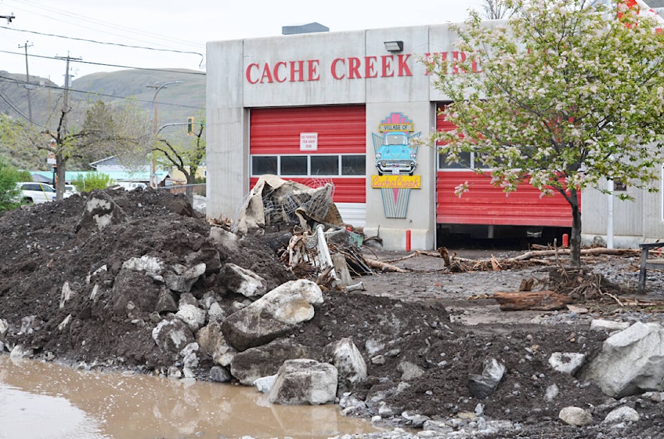
Couture notes that the washed-out material is piled two- to three-feet deep around the Tumbleweed Motel, and that the bottom of Cache Creek at the site of the culvert on Quartz Road is five feet higher than it was this time last year.
“That’s concerning. If we’re looking at putting in flood mitigation methods, like dykes or rip rap, we need to know what the erosion could look like. Will it manage it, or after every freshet will we have to remove tonnes of material? We had to move 200 dumptrucks’-full of material from around the fire hall last year. We need to look at the scope of what we’re in for in future and change our plans accordingly.”
Couture adds that the planning will also help residents along the watercourses learn how to help themselves, or whether they should do mitigation work themselves: “I’d hate for them to spend money and find it’s silted-in in a few years.”
For the public awareness and education grant, Couture says the goal is two-fold.
“We want to take the time to talk with our neighbours; reach out to community groups, area First Nations, and other local governments and have conversations about how they’ve dealt with flooding in the past and see what we can learn. For example, Bonaparte First Nation is on the same river, so what do they do?
“Then we want to amalgamate that information with what we already have, and with the geomorphological study, and get it out to the public. We’ve made attempts to disseminate this info in the past but this really helps us, because sadly it ends up being a ‘corner of the desk’ thing for small communities.”
To assist with this, the village will likely be looking to hire a consultant to handle it, so it stops being a corner of the desk job.
“Rather than having to be driven from operations, it can be driven externally to really get that message out. There will likely be more information to come on this one, as I think it will evolve over the course of executing it. We have a preliminary plan in place, but don’t have every step of the way defined. What does the public want to to know about? Phase one has to happen to determine what phase two will be.”